The Maps app on the iPhone is a powerful tool that allows you to not only find your location on a map, but also provides detailed information about the elevation of your current position. This feature can be particularly useful for hikers, climbers, and outdoor enthusiasts who need to know their altitude above sea level.
To access the elevation information on your iPhone, simply open the Maps app and zoom in to your desired location. Once you have zoomed in, you can tap on any point on the map to get a pin that shows the location’s elevation. The elevation is displayed in meters or feet, depending on your preference.
It’s important to note that the elevation displayed by the Maps app is based on GPS signals and may not be extremely precise. In fact, it is only accurate to about 30 meters. Therefore, if you need highly precise elevation information, you may need to use more specialized tools or consult local topographic maps.
In addition to providing elevation information, the Maps app can also show enhanced details for roads, buildings, landmarks, and even trees in select cities. This can be particularly helpful when navigating through unfamiliar areas or exploring new places.
To ensure that the Maps app is accurately displaying your current elevation, it is recommended to adjust the location settings on your iPhone. Simply go to Settings, then Privacy, and select Location Services. From there, you can choose to allow the Maps app to access your location only while using the app, which can help improve the accuracy of the elevation data.
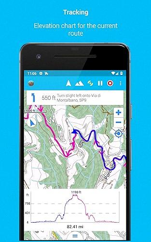
Another useful feature of the Maps app is the ability to track changes in elevation as you move. This can be particularly helpful for those who are engaging in activities such as hiking or biking, as it allows you to monitor your progress and keep track of your ascent or descent.
The Maps app on the iPhone provides a convenient and user-friendly way to access elevation information. Whether you are planning a hike, exploring a new city, or simply curious about the altitude of your current location, the Maps app can provide you with the details you need. Just keep in mind that the elevation displayed may not be extremely precise and it’s always a good idea to cross-reference with other sources if precision is crucial.
Does Apple Maps Show Elevation?
Apple Maps does show elevation. On supported models and in select cities, Maps provides enhanced detail for elevation, allowing users to view the varying heights of different locations. This feature can be useful for hikers, bikers, and outdoor enthusiasts who need to know the terrain and elevation changes in their surroundings. By displaying elevation information, Apple Maps helps users plan their routes and navigate through areas with different altitudes more effectively.

How Accurate Is IPhone Compass Elevation?
The accuracy of the iPhone compass elevation can vary depending on the specific circumstances. The iPhone compass uses a combination of GPS and barometric pressure sensors to determine elevation.
The GPS sensor is used to calculate the device’s location on the Earth’s surface, while the barometric pressure sensor measures the atmospheric pressure to estimate the device’s elevation above sea level.
However, it’s important to note that the accuracy of the iPhone compass elevation is limited. In terms of horizontal positioning, the GPS sensor is generally accurate to within a few meters. This means that the device can determine its latitude and longitude with a relatively high level of precision.
When it comes to determining elevation, the accuracy is not as precise. The barometric pressure sensor used by the iPhone compass is sensitive to changes in atmospheric pressure, which can be influenced by various factors such as weather conditions, temperature, and altitude. These factors can introduce some degree of error in the elevation measurements.
The iPhone compass elevation is typically accurate to about 30 meters, meaning that the displayed elevation may be off by around 30 meters at any given time. This level of accuracy is generally suitable for basic navigation purposes or getting a general idea of the device’s elevation above sea level.
It’s worth noting that if precise elevation measurements are required, it is advisable to use dedicated professional-grade devices or applications that are specifically designed for accurate elevation tracking purposes.
Why Is My IPhone Not Showing Elevation?
There are several possible reasons why your iPhone may not be showing elevation data. Here are some potential causes to consider:
1. Location Services: First, make sure that Location Services are enabled for your iPhone. Go to Settings, then Privacy, and select Location Services. Ensure that the toggle switch is turned on. If it’s already enabled, try toggling it off and on again to refresh the settings.
2. Compass Calibration: Elevation data on your iPhone relies on accurate compass calibration. To calibrate the compass, open the Compass app on your iPhone and follow the instructions on the screen. This should help improve the accuracy of elevation readings.
3. GPS Signal: Elevation data is determined by GPS signals, so it’s important to have a strong GPS connection. Check if your iPhone has a clear view of the sky, as buildings or other obstructions can interfere with GPS reception. Additionally, try restarting your iPhone, as this can sometimes resolve GPS-related issues.
4. Software Updates: Ensure that your iPhone’s software is up to date. Apple frequently releases software updates that include bug fixes and improvements. Go to Settings, then General, and select Software Update to check for any available updates.
5. App-Specific Settings: If you’re experiencing elevation issues with a specific app, check the app’s settings to ensure that location access is enabled. Some apps may have their own location settings that need to be adjusted separately from the general Location Services settings.
6. Hardware Issues: If none of the above solutions work, there’s a possibility of a hardware issue with your iPhone. In this case, it’s recommended to contact Apple Support or visit an Apple Store for further assistance.
Remember, these are general troubleshooting steps, and the exact cause of the issue may vary depending on your specific iPhone model and software version.
What Is The Elevation Tracking App For IPhone?
The elevation tracking app for iPhone is a useful tool that allows users to track and monitor their altitude or height from sea level. This app utilizes GPS signals to determine the user’s current location, providing accurate information about their latitude, longitude, and altitude.
Some key features of the elevation tracking app for iPhone include:
1. GPS Integration: The app utilizes GPS technology to precisely determine the user’s location, ensuring accurate altitude readings.
2. Real-Time Data: The app provides real-time updates on the user’s altitude, constantly tracking and displaying any changes in elevation as they move.
3. Altitude Graphs: The app often includes graphical representations of altitude data, allowing users to visualize their elevation changes over time.
4. Historical Data: Users can access and review their previous altitude records, enabling them to track their progress and compare elevation data from different locations or dates.
5. Barometric Pressure and Water Boiling Point: In addition to altitude, some elevation tracking apps also provide information on barometric pressure and the boiling point of water at the user’s current elevation.
6. Additional Features: Depending on the specific app, there may be additional features such as sharing altitude data with friends, setting altitude goals, or integrating with other fitness or navigation apps.
The elevation tracking app for iPhone is a valuable tool for hikers, climbers, outdoor enthusiasts, and anyone interested in monitoring and tracking their altitude. It provides accurate and real-time information, allowing users to stay informed about their elevation and make informed decisions based on their location.
Conclusion
The iPhone’s Maps app provides users with the ability to find their location on a map and zoom in and out to see the desired level of detail. While it does offer enhanced detail for elevation in select cities and supported models, it is important to note that the accuracy of the elevation data is limited to about 30 meters. Therefore, when using the app to locate an object’s elevation above sea level, there may be a margin of error of approximately 30 meters. To ensure the most accurate results, it is recommended to adjust the location settings on both the iPhone and Apple Watch by going to Settings, Privacy, Location Settings, and selecting “While Using the App” for the Compass. Additionally, it is worth mentioning that there are other apps available, such as My Altitude, that use GPS signals to determine the current location’s latitude, longitude, altitude, barometric pressure, and even the water boiling point.


